Richmond Climate vulnerability and risk assessment
Richmond, Virginia
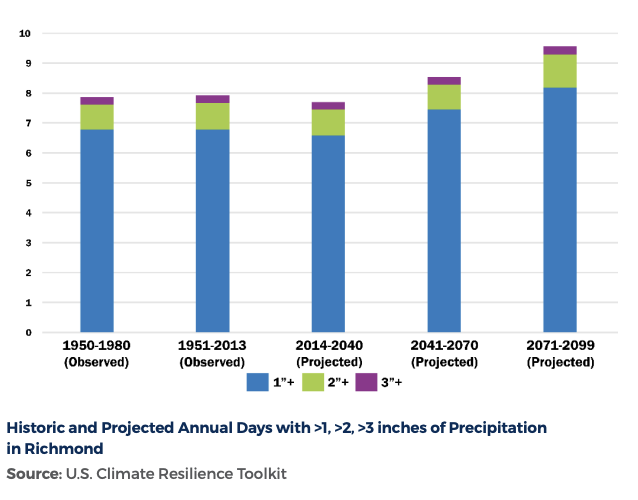
Richmond’s climate process RVAgreen 2050 is a plan to address Richmond’s changing climate and the resulting impacts. In relation to heat, Richmond is expected to have continued increases in annual average high temperatures, more days of extreme heat with temperatures reaching 95°F and higher, urban heat island effects unevenly distributed across Richmond neighborhoods, and impacts to health, increased energy demand, and higher energy costs. For Richmond’s future precipitation and storms Richmonder’s can expect for the total annual precipitation will slightly increase, heavy rain events will become more frequent and more intense, and severe and extreme storm events will be more intense and cause more flooding. Sea level rise also poses a threat as Virginia is facing the impacts of sea level rise at a greater rate than the rest of the world. While sea level rise impacts are more limited in Richmond with its inland location and topography, some areas and natural and community assets along the James River will be impacted.
Planning Communities completed the climate vulnerability and risk assessment process for the City of Richmond, VA in support of the City’s overall climate process, RVAgreen 2050. Richmond is working to address climate change and create a more equitable and resilient city for all by centering climate planning on the priorities of those most impacted by climate change including children, the elderly, and people with underlying health conditions. Recurring impacts over time have also resulted in communities of color and low-income residents bearing the brunt of climate impacts.
Planning Communities developed an extensive GIS analysis of heat and flooding risks to communities, built assets and natural features to understand how climate change is impacting Richmond communities and assets. The firm evaluated anticipated federal floodplain changes and sea level rise and application of a GIS-based flooding inundation model to account for widespread localized flooding in low-lying areas during heavy precipitation events. The final Climate Vulnerability and Risk Assessment report identified communities and assets with the greatest combined climate and social vulnerabilities and recommended and prioritized resilience and adaptation actions for implementation of the City’s Climate Equity Action Plan 2030.
A series of deliverables was developed to complement the report and communicate key information to the City and community including a StoryMap, video series and graphic handout.
All of this work by Planning Communities supports Richmond on their goals for RVAgreen 2050 where all the people of Richmond can, regardless of identity or neighborhood thrive in a climate resilient and climate neutral community.


